North Rhine-Westphalia (Nordrhein Westfalen, or NRW in German) is Germany's most populous state with almost 18 million inhabitants. The Bundesland's capital is Düsseldorf, but the state encompasses other large cities like Cologne and Dortmund as well.
NRW was at the center of Germany's Wirtschaftswunder, or "Economic Miracle" after World War II, mainly due to its coal and steel industry.
Let's start with the basics.
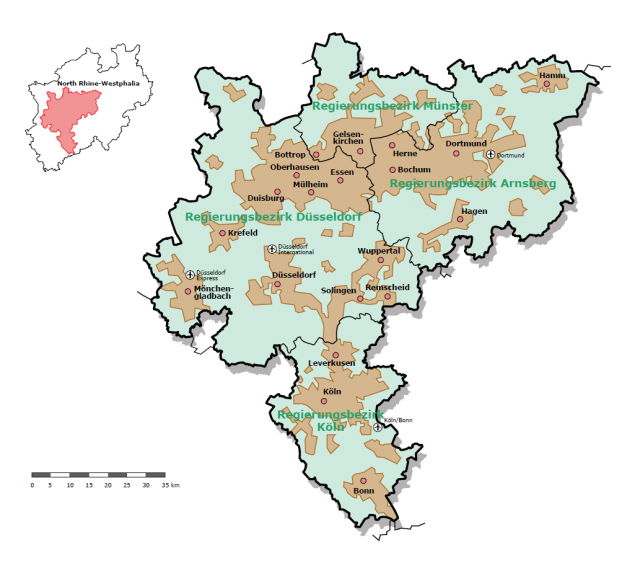
Location in Germany
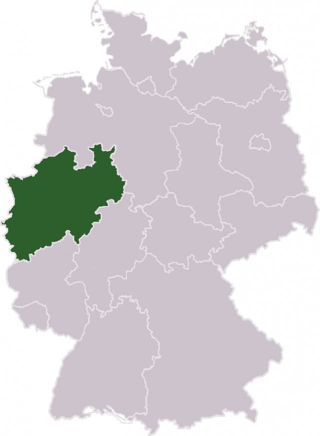
Source: Wikimedia Commons
NRW is located in Western Germany, on the border of the Netherlands and Belgium. The German state is surrounded by Rhineland-Palatinate to the South, Hesse to the Southeast and Lower Saxony to the North.
Landscape
Much of NRW is characterized by the flat plains of the Rhineland. Major rivers like the Ruhr and the Lippe are tributaries of the Rhine. NRW does reach into the central mountains (Mittelgebirge) of Germany in the Southwest.
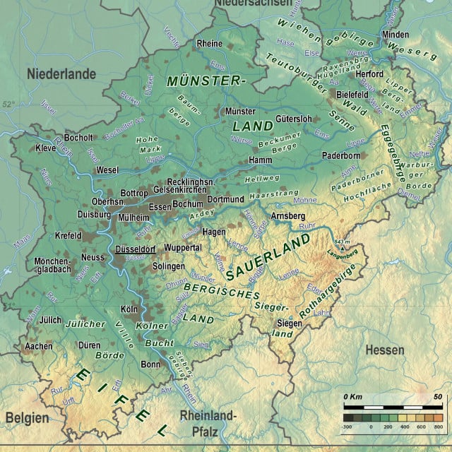
Source: TUBS via Wikimedia Commons
Historical changes
Here's a historic look at the area from 1799, when large areas of the Ruhr valley were under Prussian control and the French occupied the left bank of the Rhine. NRW didn't become an official German state until much later, when the Prussian provinces of Westphalia and the Northern Rhine were combined in 1946. This was done by British forces in "Operation Marriage." In early 1947, the free state of Lippe was incorporated as well. 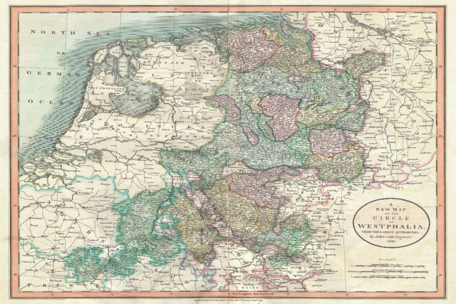
Source: John Cary/Geographicus Rare Antique Maps via Wikimedia
Industrial Engine
The area's history is tied closely to its role as the economic backbone of Post-War Germany. Once called the Land von Kohle und Stahl, or the Land of Coal and Steel, the area's industry has since undergone major changes. Many decommissioned industrial sites such as mines and furnaces are now local heritage sites. This map depicts the Rhine-Ruhr Metropolitan Area, named after two rivers crossing the heart of NRW.
Source: Bezirksregierung Düsseldorf
NRW still accounts for over 20 percent of Germany's GDP, but the industrial collapse has had lingering effects, leaving the state's unemployment higher than the national average.
Unemployment
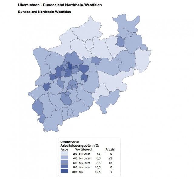
Source: Statistik und Arbeitsmarktberichterstattung der Bundesagentur für Arbeit
Unemployment in NRW was the third highest in Germany (excluding the city-states of Bremen and Berlin) at 6.4 percent as of October 2019. The average unemployment for Germany as a whole in 2019 has been between 3-5 percent. Industrial areas in the Ruhr region have generally felt the most pressure.
Dialects
Because NRW was formed from two Prussian states, the German dialects vary along the borders of the North Rhine and Westphalia.
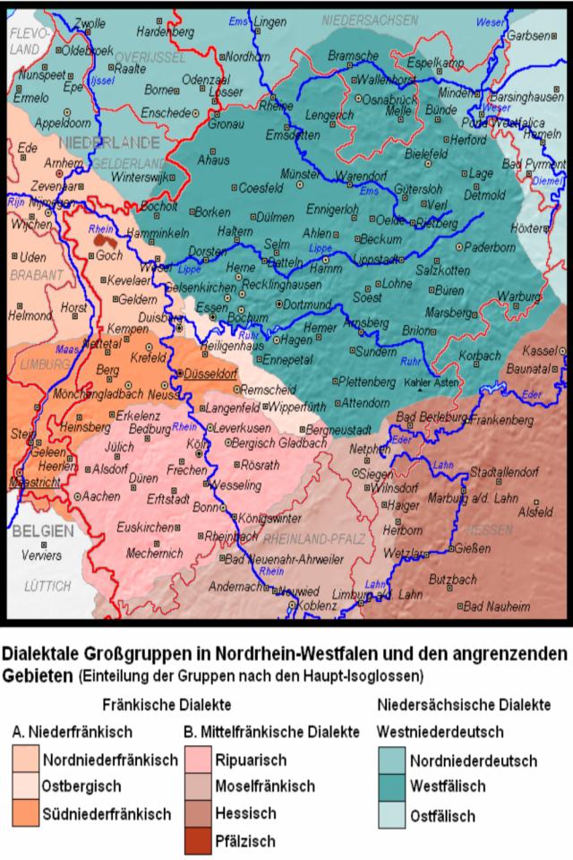
Source: Et Mikkel via German Wikipedia
Lower Saxon (Niedersächsische) dialects, also called Low German or Plattdeutsch, differentiate themselves mainly through consonant shifts. S and z sounds can be replaced with t, and ch is often replaced by k. For example, sitzen becomes sitten and machen becomes maken.
Franconian, or Fränkisch dialects are spoken through a large portion of central Germany. This dialect also has consonant shifts, but incorporates different vowel sounds as well. For example, t can be replaced by d, so Tante becomes Dande and Leute becomes Leude.
Marriage of two states
People living in the Rhineland are known to be "festive and upbeat," while their Westphalian counterparts are seen as more reserved, or, worst case, boring. The industrial Ruhrgebiet, settled between these two factions, brought the different populations together during the industrial growth of the 50s and 60s.
Comments